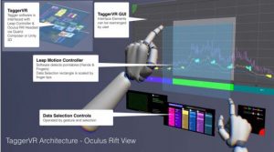
TaggerVR use a classical representation of 2D scatterplot using a VR HMD focusing on the freedom of interaction provided using a leap motion. Indeed, user make move through the geoscientific data using its bare hand. Moreover, users can select specific slice and annotate them using pre-defined tags.
Sources
[1]
P. Morse, A. Reading, C. Lueg, and S. Kenderdine, “TaggerVR: Interactive Data Analytics for Geoscience - A Novel Interface for Interactive Visual Analytics of Large Geoscientific Datasets in Cloud Repositories,” in 2015 Big Data Visual Analytics (BDVA). IEEE, sep 2015, pp. 1–2.
Entry added by Adrien Fonnet on July 31, 2018.
Category:
Temporal, VR, Tags:
HMD,