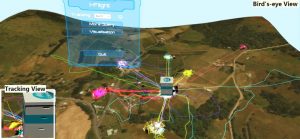
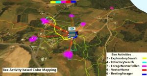
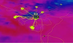
I-flight is used to visualize the result of simulation of honey bee flight data completed by real world data collected through sensor placed in the hive, e.g. brood temperature, hive weight, and hive humidity, and weather stations, e.g. solar radiation, relative humidity, wind speed, and precipitation. The hive, feeding location and bees trajectory are all placed on top of a realistic 3D map. The color of the trajectories can represent the bees’ activities or their foraging roles. A 2D heatmap can be displayed on the 3D map to represent one of the environment variables.
The navigation is available at two level, a bird eye view or a honey bee view. Choice of representation, i.e. which variable is encoded by color or which environmental variable is displayed, is done through menu selection using joystick and button from a VR controller.